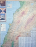
Map of Lebanon
| dc.contributor.author | Unknown | |
| dc.date.accessioned | 2019-09-21T20:24:08Z | |
| dc.date.available | 2019-09-21T20:24:08Z | |
| dc.date.issued | 1998 | |
| dc.identifier.uri | http://crdp.ddns.net:8080/xmlui/handle/123456789/2117 | |
| dc.description | A physical map of Lebanon showing its shaded relief, mountain ranges, valleys, rivers, shore, regions, plans, lakes and main roads. | en_US |
| dc.language.iso | en | en_US |
| dc.publisher | CRDP | en_US |
| dc.relation.ispartof | Geography for all levels | en_US |
| dc.rights | All Rights Reserved to the CRDP | en_US |
| dc.subject | Map of Lebanon | en_US |
| dc.subject | Geography | en_US |
| dc.subject | Physical Map | en_US |
| dc.subject | Relief | en_US |
| dc.subject | Mountains | en_US |
| dc.subject | Ranges | en_US |
| dc.subject | Valleys | en_US |
| dc.subject | Rivers | en_US |
| dc.subject | Shore | en_US |
| dc.subject | Lakes | en_US |
| dc.subject | Plans | en_US |
| dc.subject | Main Roads | en_US |
| dc.subject | Regions | en_US |
| dc.subject | Map Chart | en_US |
| dc.subject | Topography | en_US |
| dc.subject | Places | en_US |
| dc.subject | Colors | en_US |
| dc.subject | Sea | en_US |
| dc.subject | Mediterranean | en_US |
| dc.subject | Region Names | en_US |
| dc.subject | Shaded Relief | en_US |
| dc.title | Map of Lebanon | en_US |
| dc.type | Image | en_US |
| dc.type | Clipart | en_US |
| dc.type | Raster | en_US |
الملفات في هذه المادة
هذه المادة تظهر في الحاويات التالية
-
Geography [328]
Collection of images appearing in Geography books.

