Afficher la notice abrégée
| dc.contributor.author | Unknown | |
| dc.date.accessioned | 2019-10-07T14:19:08Z | |
| dc.date.available | 2019-10-07T14:19:08Z | |
| dc.date.issued | 2000 | |
| dc.identifier.uri | http://crdp.ddns.net:8080/xmlui/handle/123456789/2814 | |
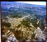
| dc.description | A sky view of the Bekaa Valley closed to the Eastern Mountain Range with its towns and planted plots. | en_US |
| dc.language.iso | en | en_US |
| dc.publisher | CRDP | en_US |
| dc.relation.ispartof | Geography for all levels | en_US |
| dc.rights | All Rights Reserved to the CRDP | en_US |
| dc.subject | Geography | en_US |
| dc.subject | Geography Of Lebanon | en_US |
| dc.subject | Sky | en_US |
| dc.subject | Nature | en_US |
| dc.subject | Bekaa Valley | en_US |
| dc.subject | Agriculture | en_US |
| dc.subject | Beqaa Governorate | en_US |
| dc.subject | Plain | en_US |
| dc.subject | Eastern Mountain Range | en_US |
| dc.subject | Towns | en_US |
| dc.subject | Lebanon | en_US |
| dc.subject | Photography | en_US |
| dc.subject | Aerial View | en_US |
| dc.subject | Built Structure | en_US |
| dc.subject | Urban Scene | en_US |
| dc.subject | City | en_US |
| dc.subject | Roads | en_US |
| dc.subject | Middle East | en_US |
| dc.subject | Urban Skyline | en_US |
| dc.subject | Planted Plots | en_US |
| dc.title | Bekaa Valley | en_US |
| dc.type | Image | en_US |
| dc.type | Photograph | en_US |
| dc.type | Clipart | en_US |
| dc.type | Raster | en_US |
Fichier(s) constituant ce document
- Nom:
- Geo_S_0078.jpg
- Taille:
- 3.158Mo
- Format:
- Image JPEG
- Description:
- High resolution raster file
Ce document figure dans la(les) collection(s) suivante(s)
-
Geography [328]
Collection of images appearing in Geography books.
Afficher la notice abrégée

